Minggu, 08 Mei 2011
Surah 4. An-Nisa' (Women) In English
In the name of Allah, Most Gracious, Most Merciful.
1. O mankind! reverence your Guardian-Lord, who created you from a single person, created, of like nature, His mate, and from them twain scattered (like seeds) countless men and women;- reverence Allah, through whom ye demand your mutual (rights), and (reverence) the wombs (That bore you): for Allah ever watches over you.

Senin, 31 Januari 2011
Borneo Sporenburg, Urban Planning Case Study in the Netherlands [Writing for Master Course, 2007]
This paper work is a continuation from the previous post: Introduction of Urban Planning: Urban Design Methods and Theories [Writing for Master Course, 2007], an assignment submitted for the Master study course Urban Design Methods and Theories of the Department of Urbanism, Faculty of Architecture, Delft University of Technology (TU Delft). This writing is not the full version of the assignment, only one case study are showed.
Borneo Sporenburg
Context
In 1996, West 8 was commissioned to transform Borneo and Sporenburg, two expansive massive docks on Amsterdam’s eastern waterfront, into residential neighborhoods with 2,500 housing units. The program called for suburban-style, low-rise housing, each with a front door opening onto the street, to be introduced into a high-density urban setting with 100 units per hectare (roughly 2.5 acres), three times the density of a typical suburban development.
 |
| Borneo Sporenburg Area View |
Actions and Achievements
Low-rise structures are arranged into strict banded blocks and sub-divided into individual parcels, each containing an inside void that comprises 30 to 50 percent of the parcel. More than 100 architects participated in the planning process, developing new housing prototypes that incorporate these voids. The resulting designs include patios, roof gardens, and striking views of the waterfront. The Borneo Sporenburg plan divides the grid of low-rise buildings in three zones with architecturally distinctive high-rise residential buildings, or “sculptural blocks,” which create significant landmarks within the harbor landscape. These sculptural blocks, informally known as the Sphinx, PacMan, and Fountainhead, also contain collective open spaces in the forms of courtyards or gardens. The water surrounding the docks serves as the dominant public space, open to Amsterdam’s boating culture.
 |
| The Area before intervention |
Committed to creating unique structures within a unified whole, West 8 worked closely with the architects who designed the various structures including O.M.A., Neutelings Riedijk, Mastenbroek, Miralles, van Berkel en Bos, and Mateo. West 8 designed the gardens and other open spaces, as well as such landscape elements as the three sculptural bridges that connect the different neighborhoods on the peninsulas, each sculptural in appearance. Borneo-Sporenburg was completed in 2000.
 |
| Borneo Sporenburg Program |
 |
| Low Bridge and High Bridge designed by West 8 |
The low-rise bars of rowhouses are broken with large housing blocks shifted at a diagonal to the streets. Geuze talks of this new housing type—high density but low rise—as a way to attract developers, satisfying the market’s need for a high number of units per acre and the consumer’s desire for a hybrid between a mid-rise apartment and a single-family detached home of the suburbs. The complex mixes social housing with market rate; some is for people with special needs, young families, single mothers, the elderly, and those needing psychiatric care. Sixty lots were sold as individual home sites and developed by the people who would live there, rather than by speculators. Costs were often defrayed by splitting the units, most often nesting one family’s unit with another. Various architects developed sections (a hybrid dream of the heroic Marseille block and the current Dutch vogue for an ambiguous—sinuous, continuous, intricate—interpretation of spaces). The variety of facades and materials, along with the interpenetration of schools, provide breaks in what could be viewed (especially in the United States) as an insistent linearity and repetitiveness.

 |
| Free Parcels and Quays challenging architects and clients |
Even in this project there was the difficulty of bringing in “outside” architects (stars), and several of the architects who were initially hired found it difficult to work with a public client. The inevitable starts and stops of funding and the approvals process take their toll. As master planner, Geuze says that he worked hard to get a varied array of architects involved, believing that it was worth the effort and political capital. There had to be faith in the designers and in the unfamiliar, though bureaucracies are by nature risk-averse, which often restricts the ability of a project to adjust, redirect, and innovate—to make the leap that is required in moving forward.
 |
| Row Houses along the Waterside |
The project is not without shortcomings. (Though it is the overwhelming success of Borneo Sporenburg and its planning that opens it to this closer scrutiny.) For instance, there is little commercial and retail development interspersed with the housing—the outcome of an agreement with the anchor commercial tenant at the edge of the housing. No small stores commingle on the blocks, requiring long walks for necessities. (even the original Levittown had small commercial centers, for the one-car families.) The public spaces seem less considered, though streets are carefully made and do refer back to an earlier Dutch type. The lack of relief in the form of mature green spaces and trees lends a sere quality to the surrounding landscape in its initial years.
Unlike the traditional model in which the developer is in the lead, here the design team devises the scheme, which is then presented to the municipality. The municipality agrees on a blueprint of its own, an overarching set of goals for physical planning. It then finds developers who will work within the broad guidelines established by the winning team of architects, landscape architects, and planners. This process differs fundamentally from most development work in the United States. It is not the developers’ fault; the public good is, literally, not their responbility. It is, however, the responsibility of civic government.
 |
| Sphinx; architect: Frits van Dongen |
In the Borneo project, there was clearly the needed professional expertise “in house”: designers who worked for the city could evaluate design proposals. This responsibility has not been “outsourced” or relinquished. In contrast, we often find U.S. housing authorities with no professional design staff; they have ceded that responsibility to the development community and have gotten out of the business of participating actively in the design of public services. At this juncture, the erosion of rights for all citizens can occur. The city is, after all, our collective public space.
 |
| Sphinx Garden; architect: Frits van Dongen |
Work such as this does not happen of its own accord. It is nurtured by support, in this case almost entirely public. Designers are commissioned to undertake public work and given the means and time to do that work. Most important, they are brought in at the beginning of the process. There is the confidence that design is not decoration, but fundamental to the rethinking of public institutions and public space. Not only are funds made available but governmental agencies actively engage emerging designers, allowing them to develop international opportunities and alliances through work on Dutch consulates overseas,. Architecture, landscape architecture, and industrial design are seen as viable exports, and ambassadors abroad.
The success of the Borneo project underscores the difficulties of making new sections of the city that are complex but conceived at one point in time. Leaving unassigned space for the incidental, accidental, spontaneous, and often fleeting colonization makes a city real.
 |
| Fountainhead; architect: Kees Christiaanse |
Back in the historic center, walking to the hotel past the large framed by the great arched passageway of the Rijksmuseum, it is not the cleverness of the landscape design or the monumental gothic revival facades that are striking (though these all contribute to the impression), but the density of activity filling the space and surrounding streets—people lying on the grass, walking, eating and biking. It is a full-color version of a contemporary city in motion. In an abstract field of angles and points, cars, trams, and people make a grand prospect of a civil society out in public.
Delft, January 2007
Sigit Kusumawijaya
Urban Design Methods and Theories: Introduction of Urban Planning
Writer: Sigit Kusumawijaya
Supervisor: Ir. Willem Hermans
Status: assignment submitted for the Master study course Urban Design Methods and Theories of the Department of Urbanism, Faculty of Architecture, Delft University of Technology (TU Delft)
Year: 2007
Writer: Sigit Kusumawijaya
Supervisor: Ir. Willem Hermans
Status: assignment submitted for the Master study course Urban Design Methods and Theories of the Department of Urbanism, Faculty of Architecture, Delft University of Technology (TU Delft)
Year: 2007
Sabtu, 04 Desember 2010
Kop van Zuid, Urban Planning Case Study in the Netherlands [Writing for Master Course, 2007]
This paper work is a continuation from the previous post: Introduction of Urban Planning: Urban Design Methods and Theories [Writing for Master Course, 2007], an assignment submitted for the Master study course Urban Design Methods and Theories of the Department of Urbanism, Faculty of Architecture, Delft University of Technology (TU Delft). This writing is not the full version of the assignment, only one case study are showed.
Kop van Zuid
 Kop Van Zuid Area View
Overview of Regeneration Scheme
Kop van Zuid (“Southern Headland”) is a peninsula on the south bank of the River Maas directly opposite Rotterdam’s city centre. It covers some 125 ha and used to be an important port area with docks, a shipyard and a terminal for ocean-going liners, but all these activities closed down when the port moved downstream to the mouth of the river during in the 1960s and 1970s, and Kop van Zuid became abandoned. It was an isolated and largely hidden area, cut off from the river by warehouses and from surrounding areas by railway lines, and was poorly connected to the city centre. The wider area in which it lies, the ‘borough’ of Feyenoord (one of Rotterdam’s 13 sub-municipalities), consists mainly of poor residential neighborhoods where the people who worked in the port and other riverside industries used to live. It now has a high level of immigrants among its population. It has traditionally been an area of low educational achievement and high unemployment, and it used to have a very poor image, which made it difficult to attract private investment or people with choice to live there.

 Satellite Map of Rotterdam (top) & Kop Van Zuid Location (bottom)
There were plans to redevelop the area for social housing, but in 1986, under a master plan commissioned by the new City Planning Director Riek Bakker, Kop van Zuid became seen as a key to unlocking huge potential for the whole city. If it was developed as a high-quality mixed-use area, with eye-catching buildings and a lively waterfront, and connected directly to the city centre, it could not only change Rotterdam’s image but also open up the entire south side of the city.
 Kop Van Zuid Area Map:
1. North bank-city centre
2. Erasmusbridge
3. The district Noordereiland (an isle in the river, belonging to the borough of Feijenoord),
4. Wilhelminapier (KvZ Area-belonging to the city centre)
5. Zuidkade (KvZ Area-belonging to the city centre)
6. Landtong (KvZ Aera-belonging to the city centre)
The plan for Kop van Zuid aimed to create a series of distinctive buildings and quarters in order to broaden the population and create new jobs in the area. Two university colleges with 10,000 students were built. The plan provided for 5,300 residential units and 400,000 sq.m. of offices, but it was flexible enough to accommodate changes in the mix as the housing market gained in strength. The redevelopment has been carried out under a phased strategy spread over several years. Although only the first part of the scheme has been completed, it has already had a dramatic impact on the area and on Rotterdam.
 Hotel New York by Night
Reuniting a Divided City
The Erasmus Bridge, the new Metro station in Kop van Zuid and extension of the tram system have linked the north and south sides of the city much more closely. By putting the main railway lines underground, the pedestrian links with the adjoining residential areas have been greatly improved, and new suburban stations have helped improve local accessibility. There is also a popular system of water taxis which cross the river and link up with various visitor attractions. Kop van Zuid is now only a few minutes from the city centre which is also now well-connected to the rest of south Rotterdam. People from the north of the river now visit the South Bank, and many of the new residents of Kop van Zuid have come from across the river as well as from the wider region. The high quality of the public realm, with direct pedestrian routes and high quality surfaces, has helped to attract people with higher incomes to live in the area, thus helping to rebalance the demographic profile, and rising property values are encouraging existing residents to stay, as the whole area is definitely ‘on the up’.
 The Louis Pregerkade and the Binnenhaven
Changing the City’s Image
Apart from the bridge, Kop van Zuid now has a number of stunning buildings. Many were designed by leading architects such as Renzo Piano, Norman Foster and Rem Koolhaas. Historic older buildings too have been restored and re-used. For example, the former Holland America line terminal has been converted into the atmospheric Hotel New York, and the oldest dock in the area has been turned into an industrial museum. The Entrepot building became a supermarket and a series of restaurants with food from around the world, so as to retain some of its previous character. Although the restaurants failed as insufficient demand had yet built up, the scheme succeeded in changing the area’s image and in attracting private investment in high quality housing.
 World Port Center, Hotel New York and Montevideo
High quality urban design has also been a notable feature (supported by Dutch planning policy in general and by Kop van Zuid’s Quality Team). Public art is used imaginatively to interpret the area’s history. The waterside has been opened up to people on foot. There is good lightning, a minimum of street clutter, and imaginative use of shared surfaces, with ample street parking in most residential areas combined with wide tree-lined pavements. The streets are kept scrupulously clean by gangs of cleaners and by the use of large receptacles into which rubbish has to be put.

Francine Houben’s Montevideo
Repositioning Rotterdam
The redevelopment of Kop van Zuid as a high quality mixed-use area close to the city centre is playing an important part in repositioning Rotterdam’s economy by making the city attractive to modern industries and to the people who work in them. Back in the 1980s the city feared that it could never compete with Amsterdam or The Hague as an office centre, let alone as a place for creative businesses. However this has now started to happen. Rotterdam was cited as one of the examples of urban renaissance by the Urban Task Force, and it won recognition as European Capital of Culture in 2001. Unemployment has fallen from 17% in 1991 to 6% in 2005 and the population of the city is slowly rising again. Much of the new employment has been created in the north west of the city (towards the airport) and many of the jobs in Kop van Zuid are in organisations that have relocated there from other parts of the city. What has succeeded in a big way is the new housing, and it has helped in attracting people with good jobs to live in the city. 40% of the residents of the area come from outside the region. These people are attracted by the prestige and convenience of the location. Furthermore, as Amsterdam is becoming more expensive and less accommodating of unconventional behavior, so Rotterdam with its new image is becoming the place for creative people to be. This is exactly what is required to reposition Rotterdam as not just a port but also a dynamic city for the 21st century.
 The New Luxor Theatre by Night
Spreading the Benefits
In the Netherlands a high priority is given to social programmes. The growth in immigration of people with low skills, combined with the changing labor market, put major pressures on Rotterdam, particularly in areas like Feyenoord. While the redevelopment of Kop van Zuid was aimed at repositioning Rotterdam for the future, there was a danger that it might leave the poorer communities right next to it largely unaffected. When the plans for Kop van Zuid were first made public, there was concern in the City Council and among the local neighborhood associations over the problems that might be caused by putting luxurious development next door o deprived areas. It was therefore agreed that a concerted effort would be made to ensure that the project also created benefits for local people. The neighborhood associations were included in the project organization, and a Mutual Benefit programme was developed to help channel as many as possible of the jobs generated by the development to local people and to improve the economies of the surrounding areas.
Delft, January 2007
Sigit Kusumawijaya
Urban Design Methods and Theories: Introduction of Urban Planning
Writer: Sigit Kusumawijaya
Supervisor: Ir. Willem Hermans
Status: assignment submitted for the Master study course Urban Design Methods and Theories of the Department of Urbanism, Faculty of Architecture, Delft University of Technology (TU Delft)
Year: 2007
Writer: Sigit Kusumawijaya
Supervisor: Ir. Willem Hermans
Status: assignment submitted for the Master study course Urban Design Methods and Theories of the Department of Urbanism, Faculty of Architecture, Delft University of Technology (TU Delft)
Year: 2007
Sabtu, 27 November 2010
Introduction of Urban Planning: Urban Design Methods and Theories [Writing for Master Course, 2007]
This paper work is an assignment submitted for the Master study course Urban Design Methods and Theories of the Department of Urbanism, Faculty of Architecture, Delft University of Technology (TU Delft). This writing is not the full version of the assignment, only Introduction chapter are showed.
I. Urban Planning
City Planning or Urban Planning, the unified development of cities and their environs. For most of its history, city planning dealt primarily with the regulation of land use and the physical arrangement of city structures, as guided by architectural, engineering, and land-development criteria. In the mid-20th century it broadened to include the comprehensive guidance of the physical, economic, and social environment of a community. Elements characteristic of city planning include (1) general plans that summarize the objectives of (and restraints on) land development; (2) zoning and subdivision controls that specify permissible land uses, densities, and requirements for streets, utility services, and other improvements; (3) plans for traffic flow and public transportation; (4) strategies for economic revitalization of depressed urban and rural areas; (5) strategies for supportive action to help disadvantaged social groups; and (6) guidelines for environmental protection and preservation of scarce resources. City planning is conducted by governments on all levels—local, country, regional, state, and federal—and by private groups.


Barcelona Moll de la Fusta project as a Revival of the design of the Urban Public Space
While urban design concerns the arrangement, appearance and functionality of towns and cities, and in particular the shaping and uses of urban public space. It has traditionally been regarded as a disciplinary subset of urban planning, landscape architecture, or architecture. However, with its increasing prominence in the activities of these disciplines, it is better conceptualized as a design practice that operates at the intersection of all three, and requires a good understanding of a range of others besides, such as urban economics, political economy and social theory.
II. Urban Planning in the Netherlands
National and Regional Policies
The Netherlands is a small, low lying and densely populated country (population 16.3 million) which is known for being neat and tidy and relatively classless. This is often attributed to the ‘polder mentality’ of people having to collaborate to maintain the dykes that keep out the sea. There has been a tradition of discouraging urban sprawl, especially into the area between the four big cities through voluntary collaboration between local authorities. Concern to reduce travel by car (and to encourage walking, bicycling and the use of public transport) has reinforced the commitment to ‘compact cities’. Furthermore, a national priority has been to upgrade the centres of the main cities in the belief that they act as dynamos for their wider city-regions.


Total planning and control of the territory to maintain the dykes that keep out the sea.
Urban Renewal
Following the housing shortages caused by the war and the influx of immigrants, the government undertook an extensive house building programme. Quickly a need to focus on inner urban areas appeared. In Rotterdam a group of elected politicians led the way by setting up local urban renewal organisations and campaigning for government-funded ‘renewal areas’ to be created. This policy was largely successful and by 1996 more than 50% of the housing stock in the renewal areas (including parts of Feyenoord) had been modernized. However this policy did not tackle unemployment of the wider social aspects of urban living. Eventually the mayors of the four large cities collectively lobbied the national government for greater support for a broad-ranging approach to urban renewal. This led to the Major Cities Policy (Grote Steden Beleid) which aimed at creating a ‘complete city’ through economic, social and physical measures and had a bottom-up approach to implementation. The outcome was a five-year funding agreement between the central government and the local authorities (municipalities) in each of the four cities, including Rotterdam. The first agreements were made in 1994. There have been two further 5-year agreements since, and the number of participating towns has increased to thirty. Each agreement sets out an agreed strategy and a financial commitment from the national government. The implementation programme is drawn up by the municipality concerned and includes a limited number of output targets. When agreement has been reached, the municipality accepts responsibility for the implementation of the programme and for the success of their town. This represents an important devolution of power and responsibility.
Decentralisation
Historically the Netherlands used to be a decentralised state, with a strong stress on local collaboration (the so-called ‘polder mentality’). Although the autonomy of local authorities had been gradually reduced during the late 19th and early 20th centuries, they still retained significant roles. After World War II, the call for a larger welfare state, and the need for large scale provision of housing and the repair of damaged urban areas, resulted in more power, and a greater share of financial resources, being taken by the central government. However, during the 1990s there was a reduction in state intervention in welfare and housing (including, for example, the promotion of owner-occupation), and a move to give more responsibilities back to local authorities so that they could make decisions and integrate activities at a more local level. The Major Cities Policy is an example of this.
Historically the Netherlands used to be a decentralised state, with a strong stress on local collaboration (the so-called ‘polder mentality’). Although the autonomy of local authorities had been gradually reduced during the late 19th and early 20th centuries, they still retained significant roles. After World War II, the call for a larger welfare state, and the need for large scale provision of housing and the repair of damaged urban areas, resulted in more power, and a greater share of financial resources, being taken by the central government. However, during the 1990s there was a reduction in state intervention in welfare and housing (including, for example, the promotion of owner-occupation), and a move to give more responsibilities back to local authorities so that they could make decisions and integrate activities at a more local level. The Major Cities Policy is an example of this.

The National Spatial Strategy (Nota Ruimte) from the Dutch Government
The result is that municipalities can be flexible in the way that they implement national policies. Central government sets the policy framework, and local authorities implement the policies in the way that best fits local circumstances. This flexibility allows local authorities to take a more proactive and entrepreneurial approach in both planning and policy implementation. In Rotterdam this has led to an ‘Integrated Area Approach’ which focuses on priority areas and tackles local employment and quality of life issues as well as making physical improvements. Great stress is now placed on ‘working together’ – involving residents, landowners, businesses, local politicians, local agencies such as housing associations etc – and on communication. Social inclusion is also given a high priority, especially because of the large number of immigrants in the city.

Randstad (upper right) competitiveness with other agglomeration in Europe: Paris (upper left), Milan (below left) and Rhine (below right)
Working together
Another important characteristic of the ‘Dutch approach’ is the ability and willingness to work through informal networks. As in Sweden and Northern France (which is Flemish in origin) the concept of working together, across professions and sectors, towards the common good is widely accepted. This appears mainly to take place in a voluntary way. Although there are many formal partnerships, it is not just the structures that are important but the attitudes of the parties involved and their ability to be flexible and co-operate at a practical level.
The Netherlands, however, does not have a formal ‘city-region’ layer of government. An experimental Rijnmond Region around Rotterdam was tried, but it failed – partly because of confusion over its role in co-ordinating policies among municipalities, and partly because it would create a fourth tier of government. A referendum was held on whether there should be a formal city-region, but this was rejected. However, the municipalities recognize that they need to co-operate in order to promote economic competitiveness and so informal city-regions (in which the individual municipalities keep their independent identities) have in fact developed around the major cities. There is also increasing collaboration across the Randstad (‘Regio Randstad’) with a view to increasing its overall international competitiveness too.
Delft, January 2007
Sigit Kusumawijaya
Writer: Sigit Kusumawijaya
Supervisor: Ir. Willem Hermans
Status: assignment submitted for the Master study course Urban Design Methods and Theories of the Department of Urbanism, Faculty of Architecture, Delft University of Technology (TU Delft)
Year: 2007
Selasa, 05 Oktober 2010
[A-a] connection | Amsterdam-Almere Connection [master project semester 1, 2006]
This work is an assignment submitted for the Master study course Perspective Spatial Development Strategies of the Department of Urbanism, Faculty of Architecture, Delft University of Technology (TU Delft).
Overall View
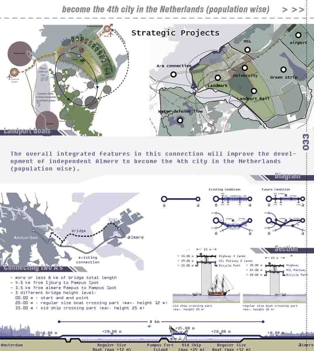
[A-a] connection is one of the strategic projects for POWERED by LANDPORT perspective theme of our group that will determine the development of Almere, the Netherlands in the future. Boosting the development of Almere needs a good accesibility. This new 8 km bridge will relieve the load of congestion problem in A1-A6 which connects Amsterdam and Almere.

The overall integrated features in this connection will improve the development of independent Almere to become the 4th city in the Netherlands (population wise).
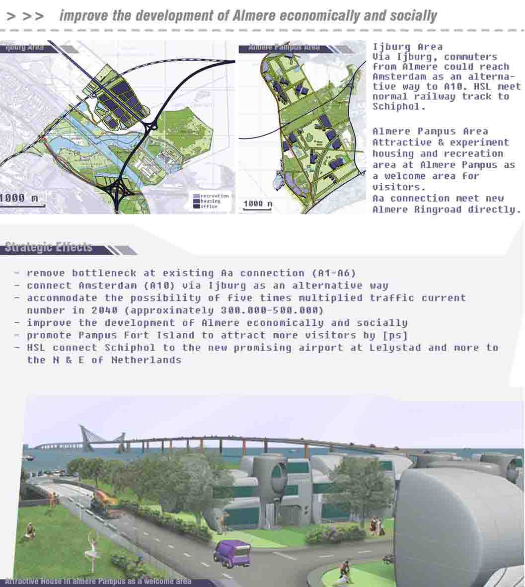
Ijburg Area
Via Ijburg, commuters from Almere could reach Amsterdam as an alternative way to A10. HSL meet normal railway track to Schiphol.
Almere Pampus Area
Attractive & experiment housing and recreation area at Almere Pampus as a welcome area for visitors.
Aa connection meet new Almere Ringroad directly.
Strategic Effects
- remove bottleneck at existing Aa connection (A1-A6)
- connect Amsterdam (A10) via Ijburg as an alternative way
- accommodate the possibility of five times multiplied traffic current number in 2040 (approximately 300.000-500.000)
- improve the development of Almere economically and socially
- promote Pampus Fort Island to attract more visitors by [ps]
- HSL connect Schiphol to the new promising airport at Lelystad and more to the N & E of Netherlands
In the larger scale, this connection will be a gateway to the North and East of the Netherlands and a new power for Randstad to compete with other agglomerations in Europe in the future.

Work Description
Title : [A-a] connection
Location : Amsterdam-Almere, the Netherlands
Status : Master Project Semester1
School : Department of Urbanism, Delft University of Technology (TU Delft), The Netherlands
Year : 2006
Langganan:
Postingan (Atom)